


This summer's Appalachian Trail section hike is across New York. Last year we section hiked all of New Jersey and stopped at NY 17A due to damaged feet. As we want to continue sectioning north, but don't want to tackle the hardest part of New York first, we're jumping ahead to Kent, CT and hiking southbound (SOBO) to NY 17A. This should give us a week to get our long distance legs and lungs developed to tackle Bear Mountain, the Lemon Squeezer, and Agony Grind the last few days.
Below is my hiking plan much as it looks on my cell phone. My safety person will also have a copy of this schedule to monitor my progress. Noting approximate times, mileage, major features, and notes on water and privy availability have proven useful the last few years. I also carry a printed copy of this hiking plan and review my progress before bed each evening.
Kent CT to NY 17A (93.1m)
DAY 1
8a
Grand Central Station
8:45a
Depart NYC ($22)
10:30 Southeast Station (transfer)
Noon
Arrive Wassaic NY (shuttle $20)
1p m1455.9
Kent CT 06757
2p m1455.5
Algo shelter - W PRIVY
4p m1452.7
Schaghticoke Mtn Campsite - W
4:30p m1452.1
Indian Rocks
6p m1448.1
Trail to Bulls Bridge
7p m1447.4
hand pump (w)
7p m1447.2
Ten Mile River Lean-to - W PRIVY
-------------------------
DAY 2 (12.7m)
11a m1444.4
Ny/CT State Line
Noon m1443.2
Wiley Shelter - w
4p m1437.6
N.Y. 22, Appalachian Trail RR Station 12564
Native Landscapes & Garden Ctr (W, shower, mail drops)
4p m1435.2
Dover Oak
6p
County 20/West Dover Road
7p m1434.5
Telephone Pioneers Shelter - W PRIVY
-------------------------
DAY 3 (7.8m)
10a m1434.0
West Mtn
Noon m1431.2
Nuclear Lake - W
2p m1430.0
N.Y. 55, Poughquag, NY 12570
E - school bus deli/hot dog stand
6p 1,426.7
Morgan Stewart Shelter - W PRIVY
-------------------------
DAY 4 (10.3m)
10a m1426.6
Mt. Egbert
2p m1422.8
N.Y. 52, Stormville, NY - (E–0.3m G, M)
5p m1417.7
RPH shelter - W PRIVY
6p m1416.4
Shenandoah Tenting Area - W
-------------------------
DAY 5 (9.4m)
Noon m1,414.9
Shenandoah Mtn
2p m1,412.0
Canopus Lake, Clarence Fahnestock State Park - W SHOWER
4p m1,410.7
NY 301
7p m1,407.0
Dennytown Rd - W
(Camping W 500 ft, S dirt road to hill)
-------------------------
DAY 6 (12.3m)
10a m1404.3
South Highland Rd
3p m1399.7
Graymoor Spiritual Life Center
W PRIVY SHOWER (donation $10)
4p m1398.3
US 9/Shell station/convenience store - W Meal FUEL
7p m1394.7
Hemlock Springs Campsite - W
-------------------------
DAY 7 (7.2m)
9a m1393.3
Bear Mtn Bridge
9:30a
USPO, Ft Montgomery 10922
(dropbox) RESUPPLY
10a m1393.2
Bear Mtn Museum/Zoo/pool
W PRIVY SHOWER Wx
Noon m1390.7
Bear Mtn - W Wx
6p m1387.5
West Mtn Shelter - NO WATER
-------------------------
DAY 8 (9.2m)
10a m1385.9
Beechy Bottom Brook - W
10a m1385.7
Palisades Interstate Pkwy
11a m1384.4
William Brien Memorial Shelter - NO WATER
1p M1381.6
Seven Lakes Parkway
3p m1379.4
Arden Valley Road - w
SHOWER / PRIVY / DINNER / FILL W BLADDER
(Tiorati Circle/Lake)
6p m1378.3
Fingerboard Shelter - NO WATER
-------------------------
DAY 9 (6.9m)
10a m1377.0
Lemon Squeezer
Noon m1375.6
Island Pond Outlet - W
2p m1373.6
Arden Mtn, Agony Grind
3p m1372.1
Orange Tpk - W (E–0.5m)
(NYC vista)
5p m1371.4
Little Dam Lake - W
NO CAMPING
-------------------------
Day 10 (8.6m)
10a m1367.8
Mombasha High Point
1a m1366.6
Fitzgerald Falls - W
Noon m1364.8 (13.5m)
Wildcat Shelter - W PRIVY
2:00p m1362.8
NY 17A - Bellvale Creamery
2:10p NJ Transit Bus ($15)
6p ARR NYC
Note the above plan can easily be modified for a shorter hike by starting at Pawling, NY; at Peekskill NY; at Fort Montgomery NY; or at Lake Greenwood NY. These are all bus and commuter train access points for the Appalachian Trail.
Showing posts with label planning. Show all posts
Showing posts with label planning. Show all posts
Thursday, May 31, 2012

Thursday, April 12, 2012
Appalachian Trail Weather from Google

To get Appalachian Trail weather reports, just open a new outgoing SMS message and send "wx" and the nearby zipcode to 466453 (GOOGLE). You'll receive a weather forecast for the next 24-48 hours from Google.
I usually depart for the Appalachian Trail with a ten day forecast from the Weather channel. One of my peeves about the trail is the lack of current weather data along my hike. Often there's a bulletin board with warnings and admonitions, but no one seems to pin-up a 72 hour forecast for long distance hikers.
This year I plan to annotate the zipcodes of nearby towns on my hiking schedule so I can get updated weather from Google as I work south along the Applachian Trail. When I send an SMS text message to my safety person following my hike, I'll take a moment and get updated weather from Google!
In addition to adding the Shenandoah NPS 24-hour emergency center (800-732-0911) to your phone's contacts, give strong consideration to adding Google SMS search.
Wednesday, November 23, 2011
Appalachian Trail Books: A Walk in the Woods by Bill Bryson

Just finished Bill Bryson's well known Appalachian Trail book, A Walk in the Woods. Someone had placed a new paperback copy in my mail box at the office. Likely because they know I've been backpacking long sections of the Appalachian Trail for a few years now. Even though Google shows 5,176 reviews for Bryson's book, here's my take on A Walk in the Woods.
First, Bryson's style is most enjoyable and he cleverly weaves facts into his narrative of his year long series of hikes along the Appalachian Trail. We learned a few things, such as the history of the Delaware Water Gap, that we would have liked to have known before our hike of the same section. (Fortunately, we have not yet sectioned Mount Greymore in MA, so we'll have a better appreciation of the war memorial and buildings when we arrive some years hence.)
Second, Bryson was faithful in recreating just how difficult, tiring, and mentally tough any long hike of the Appalachian Trail really is. We too have stood at the abyss and had to weigh our desire to continue hiking or just pack it in and go home. Anyone planning a through hike or even an extended hike of a section of the Appalachian Trail is well served by reading Bryson's book and taking seriously his recollection of just how tough the Appalachian Trail really is. There's a reason why so many hikers abandon their hike of the trail year after year. Bryson should be commended on his honest descriptions and having the integrity to reveal that he too found a through hike beyond what he wished to endure. While we have only hiked about 200 miles of the 2, 178 mile trail, like Katz and Bryson, we too have "hiked the Appalachian Trail" and will be forever changed by it.
Its an inexpensive paperback book and its found in most libraries. If you've got some time for reading, its worth it. If you want to save some cash, you can read a large excerpt of A Walk in the Woods on Google Books.
Disclosure: We select and purchase the product(s) reviewed. We have no material connection to either the manufacturer nor the retailer(s).
Monday, November 15, 2010
Section Hike: Delaware Water Gap, PA to Graymoor, NY
My 2010 section hike went so well that I'd like to continue north along the Appalachian Trail. Although I stopped at Carlisle, PA, the remaining distance in PA is more than I can likely hike in two weeks. So, I've planned to start at Delaware Water Gap (DWG) and hike to Graymoor in mid New York. This distance seems easy to make and provides nearby transportation to and from the Appalachian Trail. Ending at Graymoor also sets me up to continue sectioning from Graymoor, completing New York and Connecticut, and ending near public transportation in southwestern Massachusetts.
The basic plan is to Greyhound to New York City, switch to a Poconos casino bus, remain overnight at the Presbyterian Church of the Mountain hostel, hike north, resupply in Unionville, hike north some more, clean up at Graymoor, ride the train back to New York City and Greyhound back to Arkansas.
Based on our 2010 experience we alternated long and short days to average about 11 miles per day for the two weeks. Day one is ten miles from DWG to the Mohican Outdoor Center. Day two is shorter with an early stop at the YMCA camp. Then two nights at shelter areas and an anticipated bear encounter. We plan to use an Ursack instead of a traditional bear bag. We also might experiment with a mail drop of dehydrated goodies like chili, chipotle black beans, tuna packets, and pork ramen at Highpoint State Park.
We read this morning that a Major Brooks in the Marine Corps Reserve Force Recon is planning to thru-hike the AT next spring to raise funds for wounded veterans via the Semper Fi Fund. His online schedule puts him in the same section during mid-May. We'll try to adjust our schedule to position ourselve slightly ahead of his arrival as his schedule has him making tremendous distance each day and finishing the AT in early summer.
The basic plan is to Greyhound to New York City, switch to a Poconos casino bus, remain overnight at the Presbyterian Church of the Mountain hostel, hike north, resupply in Unionville, hike north some more, clean up at Graymoor, ride the train back to New York City and Greyhound back to Arkansas.
Based on our 2010 experience we alternated long and short days to average about 11 miles per day for the two weeks. Day one is ten miles from DWG to the Mohican Outdoor Center. Day two is shorter with an early stop at the YMCA camp. Then two nights at shelter areas and an anticipated bear encounter. We plan to use an Ursack instead of a traditional bear bag. We also might experiment with a mail drop of dehydrated goodies like chili, chipotle black beans, tuna packets, and pork ramen at Highpoint State Park.
We read this morning that a Major Brooks in the Marine Corps Reserve Force Recon is planning to thru-hike the AT next spring to raise funds for wounded veterans via the Semper Fi Fund. His online schedule puts him in the same section during mid-May. We'll try to adjust our schedule to position ourselve slightly ahead of his arrival as his schedule has him making tremendous distance each day and finishing the AT in early summer.
Tuesday, June 29, 2010
Section Hike: Harpers Ferry to Harrisburg
While not what was planned, here's the section hike schedule we actually hiked along the Appalachian Trail from Harpers Ferry, WV to Harrisburg, PA.
May 24, Mon - Harper's Ferry
May 25, Tue - Ed Garvey Shelter
May 26, Wed - Rocky Run Shelter
May 27, Thu - Annapolis Rocks
May 28, Fri - Raven Rock
May 29, Sat - Deer Lick Shelters
May 30, Sun - Rocky Mountain Shelters
May 31, Mon - Milesburn Cabin
Jun 01, Tue - Pine Grove Furnace State Park
Jun 02, Wed - Whiskey Spring
Jun 03, Thu - U.S. 11 Footbridge
You can find full details for each day of the 10-day section hike in my TrailJournal.
What would I have done different?
First, I should have planned for a shorter first day and anticipated staying at Ed Garvey Shelter. You really do want to stay at this historic monument and see the photos on the second floor.
Second, I should have done better research and stayed at the posher new Rocky Run shelter. I missed an opportunity to meet new trail friends. Remember, take the right hand (northern) blue blaze trail.
Third, I shouldn't have dawdled as long as I did at Raven Rock and PennMar park. I left Raven Rock after 9 a.m.. I stayed at Penn Mar about two hours. I should left earlier from both places and used the extra time gained to press on beyond Deer Lick to either Antietam or Tumbling Run shelters. Tumbling Run is much nicer than Antietam and worth the extra mile or so of easy trail. The extra miles from bypassing Deer Lick would have enabled me to resupply a day earlier and enjoy Quarry Gap shelter as I had originally planned.
Fourth, I really should have held at Boiling Springs as planned. Boiling Springs is a trail town to be enjoyed and savored.
Fifth, rather than stopping short at Highway 11 near Carlisle PA, I should have executed my original plan to catch the bus there and then take the bus north to Clarks Ferry. This would have emabled me to knock out an extra 30 miles in just two more days and over a weekend. Now I still have to section from Duncannon to Delaware Water Gap plus do the 30 miles between Duncannon and Carlisle PA.
May 24, Mon - Harper's Ferry
May 25, Tue - Ed Garvey Shelter
May 26, Wed - Rocky Run Shelter
May 27, Thu - Annapolis Rocks
May 28, Fri - Raven Rock
May 29, Sat - Deer Lick Shelters
May 30, Sun - Rocky Mountain Shelters
May 31, Mon - Milesburn Cabin
Jun 01, Tue - Pine Grove Furnace State Park
Jun 02, Wed - Whiskey Spring
Jun 03, Thu - U.S. 11 Footbridge
You can find full details for each day of the 10-day section hike in my TrailJournal.
What would I have done different?
First, I should have planned for a shorter first day and anticipated staying at Ed Garvey Shelter. You really do want to stay at this historic monument and see the photos on the second floor.
Second, I should have done better research and stayed at the posher new Rocky Run shelter. I missed an opportunity to meet new trail friends. Remember, take the right hand (northern) blue blaze trail.
Third, I shouldn't have dawdled as long as I did at Raven Rock and PennMar park. I left Raven Rock after 9 a.m.. I stayed at Penn Mar about two hours. I should left earlier from both places and used the extra time gained to press on beyond Deer Lick to either Antietam or Tumbling Run shelters. Tumbling Run is much nicer than Antietam and worth the extra mile or so of easy trail. The extra miles from bypassing Deer Lick would have enabled me to resupply a day earlier and enjoy Quarry Gap shelter as I had originally planned.
Fourth, I really should have held at Boiling Springs as planned. Boiling Springs is a trail town to be enjoyed and savored.
Fifth, rather than stopping short at Highway 11 near Carlisle PA, I should have executed my original plan to catch the bus there and then take the bus north to Clarks Ferry. This would have emabled me to knock out an extra 30 miles in just two more days and over a weekend. Now I still have to section from Duncannon to Delaware Water Gap plus do the 30 miles between Duncannon and Carlisle PA.
Monday, May 10, 2010
Backpacking Light: The Backyard Shakedown
While one of the secrets to backpacking light is to select lightweight gear, the greater secret is to know how to use your light backpacking gear and to ensure that you have the right mix of light backpacking gear. We're still trying to settle on a sleeping system for a late Spring section hike along the middle of the Appalachian Trail. We bought a 1-1/2 lb poncho liner to try as a replacement for a larger 3 lb sleeping bag. So, we decided to hold a dress rehearsal in the backyard.
We "hiked" our loaded lightweight Arrowhead backpack to the backyard about 10 p.m.. Using the mini LED headlight, we setup the GT lightweight travel hammock and Slap Strap micros. Rigged the camo tarp above the hammock and staked the corners down. Put the foam pad into the hammock; inflated our travel pillow and tucked it between tarp and tarp line; and covered the hammock with the poncho liner.
We also bear bagged our food bag using the PCT technique and a low hanging branch on the apple tree. Not high enough for bears, but safe from rodents, possums, and the family dog. (The trail is not the place to discover that one has forgotten, or not mastered, how to bear bag ones precious food.) We then clipped the largely empty backpack to the head end of the hammock to get it off the ground.
We sat on the hammock and donned our lightweight 50/50 long underwear over our shorts and t-shirt. Placed our shoes under the hammock and laid down. Tucked a corner of the poncho liner under the foot end of the pad and pulled it snug. Material was overhanging and touching the ground - not good. Decided to tuck the extra material on the sides under the foam pad as well. We were comfortably warm and went to sleep.
We were awaken at about four or five in the morning. 8 mph winds were lifting the tarp and blowing across the top of the poncho liner. We could actually feel the heat leaving the enclosed space around us. Also, we noted our foam pad had slipped and was now hanging over the hammock and beyond the tarp. Got out; replaced the foam pad; and re-staked the tarp closer to the hammock and ground. Also swung the backpack under the hammock and fastened the waist belt over the hammock to help keep the pack out of any rain. Went back to sleep after re-tucking the poncho liner.
We awoke after sunrise to rain hitting the tarp. Snivel meter read 54F. We were comfortable, unlike an earlier field test of a small,lightweight, fleece sleeping bag. Checked for rain penetration. Inside of tarp was dry, as were the hammock, pad, and poncho liner. We then decided to practice breaking camp in the rain. Retrieved the backpack. Stuffed the poncho liner into a compression bag and packed it away. Rolled up the foam pad and placed next to pack. Grabbed the hammock system stuff sack and stuffed the hammock and the two Slap Strap micros. Decided to leave the tarp and food bag hung until they had a chance to air dry. Had this been an actual long distance hike, we could have packed up while keeping everything critical dry.
Other than buying a new foam pad to cut down to fit the hammock, we are done acquiring and testing gear. We've settled on our cooking system: vintage aluminum pot w/lid and handle; super cat alcohol stove, spork, plastic bowl with lid, cup, and a freezer bag cozy. We plan to just boil water and use freezer bag cooking for breakfast and supper. While monitoring the weather, we'll plan our meals and start shopping for food.
Next weekends forecast is for three days of rain. We may decide to practice setting up camp in the rain as we need to make mistakes now and not later on the trail, away from the safety of home and hearth.
Our current gear list is located just below the photo and biography in the lower right blue area.
We "hiked" our loaded lightweight Arrowhead backpack to the backyard about 10 p.m.. Using the mini LED headlight, we setup the GT lightweight travel hammock and Slap Strap micros. Rigged the camo tarp above the hammock and staked the corners down. Put the foam pad into the hammock; inflated our travel pillow and tucked it between tarp and tarp line; and covered the hammock with the poncho liner.
We also bear bagged our food bag using the PCT technique and a low hanging branch on the apple tree. Not high enough for bears, but safe from rodents, possums, and the family dog. (The trail is not the place to discover that one has forgotten, or not mastered, how to bear bag ones precious food.) We then clipped the largely empty backpack to the head end of the hammock to get it off the ground.
We sat on the hammock and donned our lightweight 50/50 long underwear over our shorts and t-shirt. Placed our shoes under the hammock and laid down. Tucked a corner of the poncho liner under the foot end of the pad and pulled it snug. Material was overhanging and touching the ground - not good. Decided to tuck the extra material on the sides under the foam pad as well. We were comfortably warm and went to sleep.
We were awaken at about four or five in the morning. 8 mph winds were lifting the tarp and blowing across the top of the poncho liner. We could actually feel the heat leaving the enclosed space around us. Also, we noted our foam pad had slipped and was now hanging over the hammock and beyond the tarp. Got out; replaced the foam pad; and re-staked the tarp closer to the hammock and ground. Also swung the backpack under the hammock and fastened the waist belt over the hammock to help keep the pack out of any rain. Went back to sleep after re-tucking the poncho liner.
We awoke after sunrise to rain hitting the tarp. Snivel meter read 54F. We were comfortable, unlike an earlier field test of a small,lightweight, fleece sleeping bag. Checked for rain penetration. Inside of tarp was dry, as were the hammock, pad, and poncho liner. We then decided to practice breaking camp in the rain. Retrieved the backpack. Stuffed the poncho liner into a compression bag and packed it away. Rolled up the foam pad and placed next to pack. Grabbed the hammock system stuff sack and stuffed the hammock and the two Slap Strap micros. Decided to leave the tarp and food bag hung until they had a chance to air dry. Had this been an actual long distance hike, we could have packed up while keeping everything critical dry.
Other than buying a new foam pad to cut down to fit the hammock, we are done acquiring and testing gear. We've settled on our cooking system: vintage aluminum pot w/lid and handle; super cat alcohol stove, spork, plastic bowl with lid, cup, and a freezer bag cozy. We plan to just boil water and use freezer bag cooking for breakfast and supper. While monitoring the weather, we'll plan our meals and start shopping for food.
Next weekends forecast is for three days of rain. We may decide to practice setting up camp in the rain as we need to make mistakes now and not later on the trail, away from the safety of home and hearth.
Our current gear list is located just below the photo and biography in the lower right blue area.
Wednesday, March 24, 2010
Appalachian Trail Data Book on Google Calendar
While playing with Google Calendar, I discovered how to create my own personal Appalachian Trail Data Book or page.
1) Create a new calendar. I named mine "AT Trail".
2) Add a new event for each trail feature you wish to include.
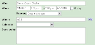
a. What: shelter name, scenic feature, road intersection, etc.
b. Uncheck all day box to right of date. This should enable entering start and finish dates and times.
c. When: Planned date and estimated time of arrival
d. to select 0 hours for a checkpoint, set delay for other events (photos, resupply, shower, etc.)
e. Where: put the mileage from Springer (e.g.; m1126.3)
3) View agenda. You now have a brief personalized data book page. One problem: Google Calendar doesn't print agendas, just calendars.

4) Copy the agenda to the clipboard.
5) Paste into favorite word processor. I pasted into Word and then used bold and other tools to improve layout and to highlight key events (resupply, showers).
Tip: By having your trip plan on Google Calendar, you can share your calendar with others. Meaning, they can import your trip plan directly into their Google Calendar.
1) Create a new calendar. I named mine "AT Trail".
2) Add a new event for each trail feature you wish to include.

a. What: shelter name, scenic feature, road intersection, etc.
b. Uncheck all day box to right of date. This should enable entering start and finish dates and times.
c. When: Planned date and estimated time of arrival
d. to select 0 hours for a checkpoint, set delay for other events (photos, resupply, shower, etc.)
e. Where: put the mileage from Springer (e.g.; m1126.3)
3) View agenda. You now have a brief personalized data book page. One problem: Google Calendar doesn't print agendas, just calendars.

4) Copy the agenda to the clipboard.
5) Paste into favorite word processor. I pasted into Word and then used bold and other tools to improve layout and to highlight key events (resupply, showers).
Tip: By having your trip plan on Google Calendar, you can share your calendar with others. Meaning, they can import your trip plan directly into their Google Calendar.
Subscribe to:
Posts (Atom)


