Click for Dawsonville, Georgia Forecast Click for Damascus, Virginia Forecast Click for Harpers Ferry, West Virginia Forecast Click for Gorham, New Hampshire Forecast Click for Millinocket, Maine Forecast

Tuesday, November 23, 2010

Hiking Trails: Ouachita Trail in Arkansas

In preparation for our 2011 Appalachian Trail section hike in New Jersey and New York, we have started improving our hiking fitness by hiking sections of the Ouachita National Recreation Trail here in Arkansas. The trail is about 223 miles long and runs from just west of Little Rock into Oklahoma.

Our wife is a historical re-enactor and was taking a Dutch oven cooking class, so we tagged along, as the Ouachita Trail begins/ends less than 50 yards from her class. We were surprised at how far we were able to travel in just four hours. We completed all of the Ouachita Trail in the state park and then several more miles. If we hadn't needed to return to the park, we'd have been a third of the way around Lake Maumelle, a large watershed lake adjacent to the state park.

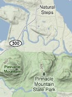
Starting at the Pinnacle Mountain State Park visitor center, the Ouachita begins a steep downhill towards the Big Maumelle River. The water bars in this section are railraod ties with considerable vertical distance. After crossing a park raod and making several turns on the way down, the trail is very flat and follows the river course. Several over-blazed stones identify a turn southwest, which also is flat and crosses under a large powerline and a railroad track. After crossing the tracks, the trail makes a sharp turn south and crosses the road intothe East Summit parking area. We took a quick rest stop at the parking area on some boulders, checked the fit of our boots, gulped some water and loaded our pants pockets with snacks.

From the East Summit parking lot, the Ouachita Trail merges with several park trails and circles north and west around the base of Pinnacle Mountain. The trail exits the state park at the intersection of Highway 300 and the main access road. The trail then follows Highway 300 across several bridges. The old highway bridge has been left for hikers. The steel barricades provide great seating for a quick break and contemplation.

After crossing the last bridge, in a traffic lane, the Ouachita Trail makes a sharp turn west and follows the overflow spillway to the lake. The trail here is flat and meanders a bit at first. We passed behind a church, which caused us to consider asking them to start a weekend evening hostel/camping ministry as there is no legal camping in the area of the trail. After leaving the church, the trail follows the spillway and adjacent Spillway Road. We noted an access point with official signage on Spilway Road just about a quarter mile from the spillway dam itself. Atop the dam there is a concrete butress that provides seating for one with good views of both sides of the spillway. This was our turn around point.

You can find a good description of part of our walk along with several good photos on the Ouachita Hiking Journal. So, we now have less than 220 miles left to complete the Ouachita Trail.

Monday, November 22, 2010

Trail Food: Starkist Tuna Salad

Restocking the office pantry a week ago, we grabbed our usual half dozen pouches of tuna. We like tuna pouches for both office and trail due to their ease of use. Just rip open a pouch, add condiments to taste, and eat! While we have seen the new flavored tuna pouches, we noted a new tuna product from Starkist - tuna salad. We tossed a pouch in our cart for review here on the blog.

Starkist tuna salad is premixed tuna and condiments in one convenient pouch. The ingredients list tuna, water chestnuts, celery, dill relish, white vinegar, sugar, salt, onion powder and egg yolks. With the exception of the water chestnuts and vinegar, the ingredient list reads much like the tuna salad our mother made for us many years ago.

We ate our tuna salad much like we would on the trail. We started with some hot pork ramen soup, which we always have with trail dinners. We then ripped open our pouch of tuna salad and dug in. Crunchy. Definitely crunchy. We could taste the celery and the bitter bite of the vinegar. As we hadn't yet read the ingredients, we assumed the crunch was celery, of which we are not fond. It was only when we paused to examine a fork full of tuna salad we discovered the pearly chunks of water chestnuts and relatively little celery. We decided today at lunch that we are not a fan of water chestnuts in our tuna salad. In fact, we decided that we would rather stick with packing pouches of plain tuna in water or oil and then seasoning the enclosed tuna with mayonnaise and pepper to our own taste. Sorry, Charlie. We like you just as you are/were.

As we know that individual tastes differ, Starkist tuna salad maybe just what you want in a trail food. We can see the advantage of one piece of trash to pack out versus multiple condiment packets. As the cost of Starkist's tuna salad is about a dollar, we recommend you buy a pouch on your next grocery run and give it a taste.

Disclosure: We select and purchase the product(s) reviewed. We have no material connection to either the manufacturer nor the retailer(s).

Monday, November 15, 2010

Section Hike: Delaware Water Gap, PA to Graymoor, NY

My 2010 section hike went so well that I'd like to continue north along the Appalachian Trail. Although I stopped at Carlisle, PA, the remaining distance in PA is more than I can likely hike in two weeks. So, I've planned to start at Delaware Water Gap (DWG) and hike to Graymoor in mid New York. This distance seems easy to make and provides nearby transportation to and from the Appalachian Trail. Ending at Graymoor also sets me up to continue sectioning from Graymoor, completing New York and Connecticut, and ending near public transportation in southwestern Massachusetts.

The basic plan is to Greyhound to New York City, switch to a Poconos casino bus, remain overnight at the Presbyterian Church of the Mountain hostel, hike north, resupply in Unionville, hike north some more, clean up at Graymoor, ride the train back to New York City and Greyhound back to Arkansas.

Based on our 2010 experience we alternated long and short days to average about 11 miles per day for the two weeks. Day one is ten miles from DWG to the Mohican Outdoor Center. Day two is shorter with an early stop at the YMCA camp. Then two nights at shelter areas and an anticipated bear encounter. We plan to use an Ursack instead of a traditional bear bag. We also might experiment with a mail drop of dehydrated goodies like chili, chipotle black beans, tuna packets, and pork ramen at Highpoint State Park.

We read this morning that a Major Brooks in the Marine Corps Reserve Force Recon is planning to thru-hike the AT next spring to raise funds for wounded veterans via the Semper Fi Fund. His online schedule puts him in the same section during mid-May. We'll try to adjust our schedule to position ourselve slightly ahead of his arrival as his schedule has him making tremendous distance each day and finishing the AT in early summer.